
East Midlands map.png
From Halal Explorer

Size of this preview: 561 × 599 pixels. Other resolutions: 225 × 240 pixels | 449 × 480 pixels | 562 × 600 pixels | 719 × 768 pixels | 959 × 1,024 pixels | 2,400 × 2,563 pixels.
Original file (2,400 × 2,563 pixels, file size: 1.55 MB, MIME type: image/png)
This is a file from the Wikimedia Commons and may be used by other projects. Information from its description page there is shown below.
Commons is a freely licensed media file repository. |
Summary
| Description |
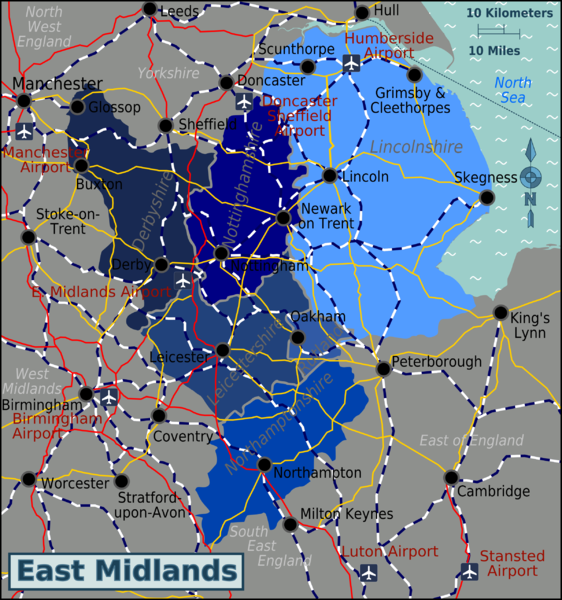
Map of the East Midlands showing counties and major cities Source: Image:East_Midlands_map.svg & :Image:UK map.svg
|
| Date | 30 November 2006 (original upload date) |
| Source | |
| Author | User: (WT-shared) Paul. at wts wikivoyage |
| Location | East Midlands |
Licensing
This file is licensed under the Creative Commons Attribution-Share Alike 1.0 Generic license.
- You are free:
- to share – to copy, distribute and transmit the work
- to remix – to adapt the work
- Under the following conditions:
- attribution – You must give appropriate credit, provide a link to the license, and indicate if changes were made. You may do so in any reasonable manner, but not in any way that suggests the licensor endorses you or your use.
- share alike – If you alter, transform, or build upon this work, you must distribute the resulting work under the same license as the original.
Original upload log
| This file was imported from Wikivoyage WTS. |
The original description page was here. All following user names refer to wts.wikivoyage-old.
- 2006-11-30 19:50 (WT-shared) Paul.[dead link] 1009×1224 (35062 bytes) Map of the East Midlands showing counties and major cities Source: [[:Image:UK map.svg]] {{location|East_Midlands}} (Import from wikitravel.org/shared)
- 2012-04-11 16:21 (WT-shared) Travelpleb[dead link] 2400×2563 (1627455 bytes) {{Imagecredit|credit=Travelpleb|captureDate=11th April 2012|location=East Midlands|source=East_Midlands_map.svg|caption=The East Midlands|de (Import from wikitravel.org/shared)
File history
Click on a date/time to view the file as it appeared at that time.
| Date/Time | Thumbnail | Dimensions | User | Comment | |
|---|---|---|---|---|---|
| current | 04:25, 13 December 2012 | | 2,400 × 2,563 (1.55 MB) | OgreBot | (BOT): Reverting to most recent version before archival |
File usage
The following page links to this file: