
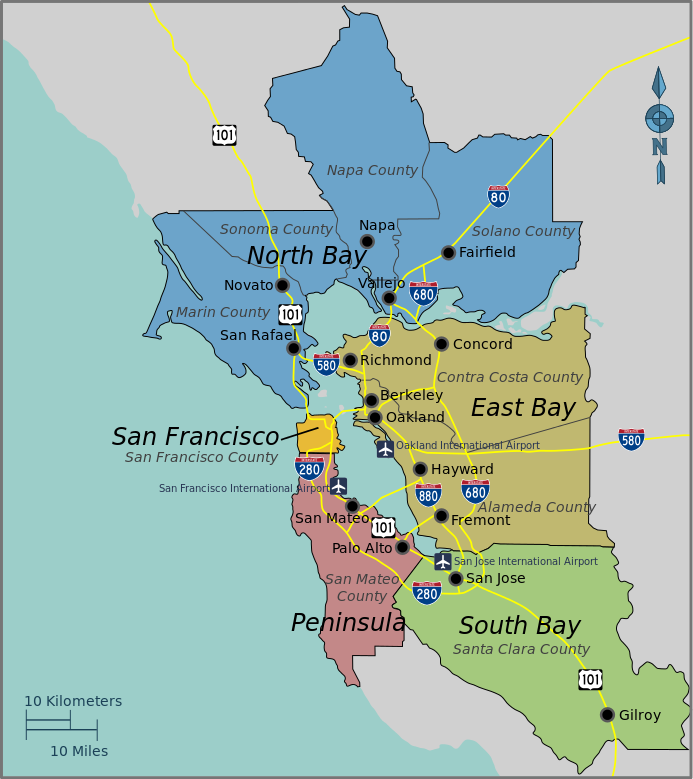
Bayarea map.svg
From Halal Explorer

Size of this PNG preview of this SVG file: 533 × 599 pixels. Other resolutions: 213 × 240 pixels | 427 × 480 pixels | 534 × 600 pixels | 683 × 768 pixels | 911 × 1,024 pixels | 693 × 779 pixels.
Original file (SVG file, nominally 693 × 779 pixels, file size: 296 KB)
This is a file from the Wikimedia Commons and may be used by other projects. Information from its description page there is shown below.
Commons is a freely licensed media file repository. |
Summary
| Description |
English: Bay Area Regions Map, Bay Area (California). |
| Date | |
| Source | Open Street Map and the PD Wikivoyage template |
| Author | PerryPlanet |
| This work contains information from OpenStreetMap, which is made available under the Open Database License (ODbL).
The ODbL does not require any particular license for maps produced from ODbL data. Prior to 1 August 2020, map tiles produced by the OpenStreetMap Foundation were licensed under the CC-BY-SA-2.0 license. Maps produced by other people may be subject to other licences. |
This W3C-unspecified vector image was created with Inkscape .
Licensing
| This work has been released into the public domain by its author, User: (WT-shared) PerryPlanet at wts wikivoyage. This applies worldwide. In some countries this may not be legally possible; if so: User: (WT-shared) PerryPlanet at wts wikivoyage grants anyone the right to use this work for any purpose, without any conditions, unless such conditions are required by law.
|
Original upload log
| This file was imported from Wikivoyage WTS. |
The original description page was here. All following user names refer to wts.wikivoyage-old.
- 2010-10-17 03:38 (WT-shared) PerryPlanet[dead link] 744×1052 (677515 bytes) {{Imagecredit|credit=PerryPlanet|captureDate=10/16/2010|location=Bay Area (California)|source=Open Street Map and the PD Wikitravel template (Import from wikitravel.org/shared)
File history
Click on a date/time to view the file as it appeared at that time.
| Date/Time | Thumbnail | Dimensions | User | Comment | |
|---|---|---|---|---|---|
| current | 10:06, 21 November 2015 | | 693 × 779 (296 KB) | Hdamm | fixed image dimensions, clean up |
File usage
The following page links to this file: