
Upper Missouri River Breaks National Monument
From Halal Explorer
Upper Missouri River Breaks National Monument, called "The Breaks" by local residents, is a United States National Monument protecting the Missouri Breaks of central Montana. It is managed by the Bureau of Land Management.
Upper Missouri Breaks NM (8914214495) - Upper Missouri Breaks NM
Contents
- 1 Upper Missouri River Breaks National Monument Halal Travel Guide
- 2 Travel as a Muslim to Upper Missouri River Breaks National Monument
- 3 Fees and permits
- 4 Get Around
- 5 What to See
- 6 What to Do
- 7 Muslim Friendly Shopping in Upper Missouri River Breaks National Monument
- 8 Halal Restaurants in Upper Missouri River Breaks National Monument
- 9 eHalal Group Launches Halal Guide to Upper Missouri River Breaks National Monument
- 10 Muslim Friendly Hotels
- 11 Stay Safe
- 12 News & References Upper Missouri River Breaks National Monument
- 13 Explore more Halal friendly Destinations from Upper Missouri River Breaks National Monument
Upper Missouri River Breaks National Monument Halal Travel Guide
From Fort Benton to the Charles M. Russell National Wildlife Refuge and the monument spans 149 miles of the Upper Missouri River and the adjacent Breaks country, and portions of Arrow Creek, Antelope Creek, and the Judith River.
The Missouri is the longest river in the United States, flowing more than 2,500 miles from its source on the eastern slope of the Rocky Mountains (United States of America)|Rockies near Three Forks, Montana, to its confluence with the Mississippi River at St. Louis, Missouri.
History
The Breaks country was a model for many of the paintings done by painter Charles M. Russell. The area has remained largely unchanged in the nearly 200 years since Meriwether Lewis and William Clark traveled through it on their epic journey.
Created by Proclamation by President William J. Clinton on January 17, 2001, it encompasses 495,502 acres (200,523 ha). The adjacent Missouri River was designated a Wild and Scenic River in 1976 and forms a western boundary while the Charles M. Russell National Wildlife Refuge is to the east.
Congress designated 149 miles of the Upper Missouri (UMNWSR) as a component of the National Wild and Scenic River System in 1976, calling it an irreplaceable legacy of the historic American west. Congress further stated that the river, with its immediate environments, possesses outstanding scenic, recreational, geological, fish and wildlife, historic, cultural, and other similar values. BLM was directed to preserve the Upper Missouri River in a free-flowing condition and protect it for the benefit of present and future generations.
The UMNWSR boundary starts at Fort Benton, Montana, and runs 149 miles downstream ending at the James Kipp Recreation Area.
How is the Landscape of Upper Missouri River Breaks National Monument
The Breaks is a series of badland areas characterized by rock outcroppings, steep bluffs and grassy plains. The valley of the Upper Missouri was originally laid down in horizontal layers and the sediments and shorelines of a great inland sea that once covered most of the Great Plains. These layers have since been folded, faulted, uplifted, modified by volcanic activity and sculpted by glaciers. Erosion then added to the variety seen along the river today, a landform known as the Breaks.
Flora and fauna
The Breaks is home to at least 60 mammal species and hundreds of bird species. Willows and shrubs are found along the Missouri River banks while sagebrush and short grass prairie are dominant elsewhere.
Forty-nine species of fish (ranging from 1/2-oz minnows to 140-lb paddlefish) reside in the river. Fishermen are most likely to catch goldeye, drum, sauger, walleye, northern pike, channel cat, carp, and small mouth buffalo. Of the six remaining paddlefish populations in the United States and the Upper Missouri's appears to be the largest in average size. Generally only taken by snagging in the spring during upstream spawning runs and they are excellent table fare. Occasionally floaters may see these lunkers roll on the surface. Other unusual species in the river are the endangered pallid sturgeon and shovel nose sturgeon.
Pronghorn antelope and mule deer are the most prevalent on the bench land above the river. You may also see beaver, coyotes, bald and golden eagle, white-tailed deer, and the occasional bighorn sheep while you are floating the river.
How is the Climate in Upper Missouri River Breaks National Monument
The area has a semi-arid climate with cold, dry winters and hot, wetter summers.
Travel as a Muslim to Upper Missouri River Breaks National Monument
The Missouri Breaks Interpretive Center is located at 701 7th Street, Fort Benton, Montana. From Great Falls (Montana)|Great Falls: Travel on U.S. 87 north for 40 miles to Fort Benton. Once in town, turn left onto 13th Street and right on Front Street. Take Front Street to 7th and turn left.
From Glacier National Park: Follow U.S. 2 to Highway 223 in Chester. Travel south on Hwy 223 for 54 miles to Fort Benton. Once in town, turn left on 13th Street and right on Front Street. Take Front Street to 7th and turn left.
Travelling from Lewistown (Montana)|Lewistown: Travel west on U.S. 200 to Stanford. Turn right (north) on Highway 80 and travel 57 miles to Fort Benton. In town, turn left on Front Street. Take Front Street to 7th and turn left.
The Missouri Breaks National Back Country Byway consists of gravel roads and unsurfaced roads that become totally impassable when wet. Check the weather, and do not attempt to travel the Byway if wet weather is threatening. Even a brief shower can turn the dirt roads into "gumbo" which is extremely slick and binds tenaciously to everything it contacts. Even a 4-wheel drive vehicle and the obvious choice for most back country travel, is no match for the clinging mud. There are no services along thyoe Byway, so be sure you have plenty of fuel, water and other crucials. There is no cell phone service.
Fees and permits
There are camping fees at the river launch sites where improved facilities are available. There are river use fees of $5 per boat for a single day trip, or $4 per person per day for multiple day trips. If your group size is more than 30, or you charge a fee for your services and then you must also apply for a Special Recreation Permit by contacting the Fort Benton River Management Station at (877) 256-3252.
Get Around
Vast portions of the monument are serviced only by graveled and unimproved roads. Much of the monument is not accessible by any road, inviting visitors to explore on foot or by boat on the Missouri River. In some areas and the BLM lands are intermingled with State of Montana lands and private property. Respect the rights of private land owners, and do not trespass.
Visitors are encouraged to visit the Missouri Breaks Interpretive Center, 701 7th Street, Fort Benton, MT 59442. Staff will be able to assist with maps, local outfitters, closure information, and general safety tips.
Public access to the Upper Missouri River is limited, so you need to plan ahead about where you will put in and take out. Private landowners along the river are able to enter the river from their own land, but visitors must use the developed public access sites. Principal launch points are: Fort Benton Canoe Launch (mile 0), Fort Benton Motorboat Launch (mile 1), Wood Bottom (mile 20.3), Coal Banks Landing (mile 41.5), Judith Landing (mile 88.5), and James Kipp Recreation Area (mile 149). Additional launch opportunities at Virgelle Ferry (mile 39.1) and McClelland (or Stafford) Ferry (mile 101.8) make feasible trips of various lengths.
Travelling the Byway
The Byway begins at the community of Winifred, 38 miles north of Lewistown on Montana Highway 236. From Winifred travel east on the DY Trail Road roughly 12 miles to a junction of the Byway's two major routes, DY Trail Road to the north and the Knox Ridge Road which continues eastward. The Knox Ridge Road is an all-weather road with gentle grades except within the C.M. Russell National Wildlife Refuge. The road within the Refuge is not surfaced and can turn into gumbo and become impassable when wet. The Knox Ridge Road provides glimpses into the Missouri Breaks and superb prairie scenery. Most of the DY Trail Road is not surfaced and penetrates into the more rugged "breaks" country along the uplands of the river. The Byway can be exited from the Wildlife Refuge junction to U.S. Highway 191. The last couple of miles of this unsurfaced road are very steep and narrow.
What to See


- Cow Creek flows into Missouri, near Cow Island in Missouri Breaks, Blaine County, Montana -
Cow Creek flows into the Missouri
.jpg)
.jpg)

What to Do
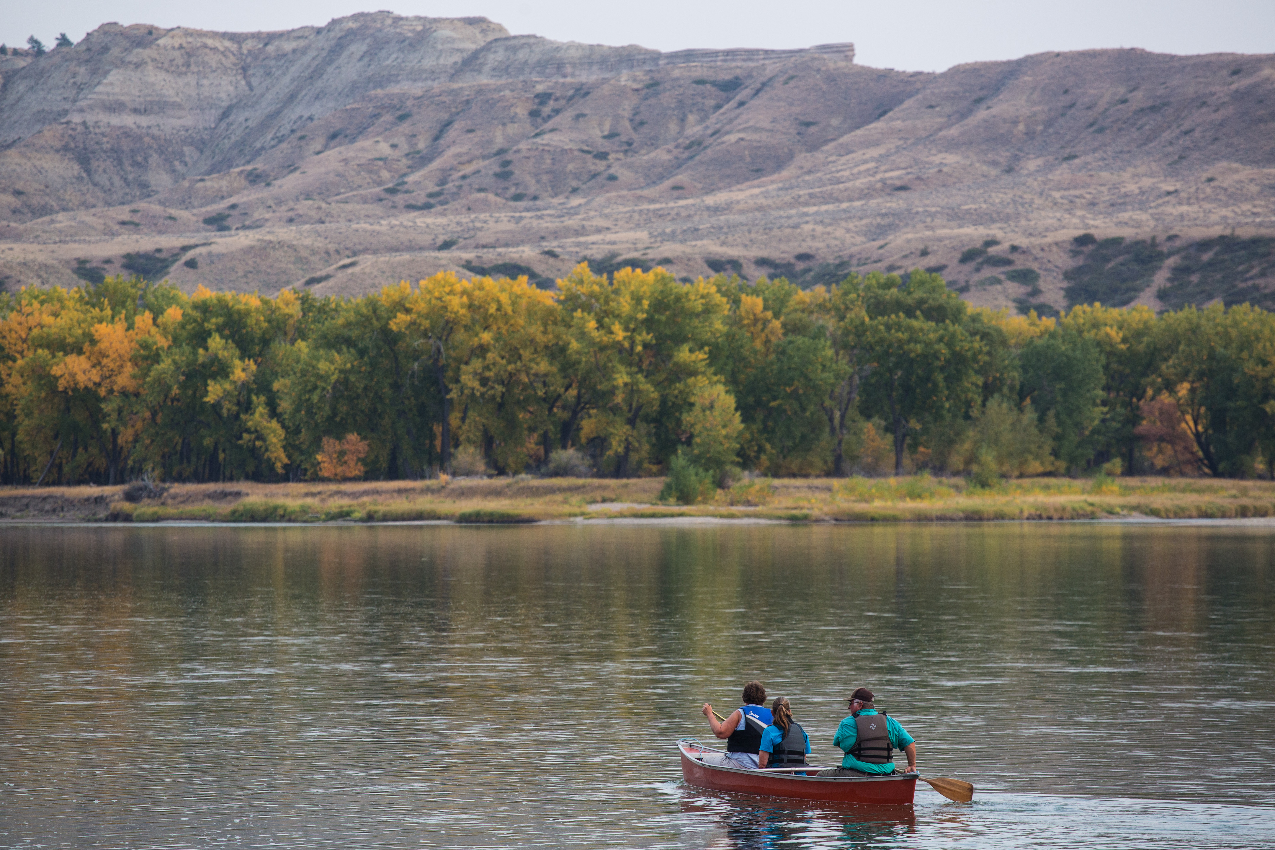
The most popular activity is to float all or parts of the 149-mile Wild & Scenic river. The most popular stretch to float is the 44-mile reach from Coal Banks Landing to Judith Landing, traveling through the spectacular white cliffs. This normally is traveled in 3-4 days, camping in remote primitive campsites along the river. The more ruggedly remote lower stretch is from Judith Landing to James Kipp Recreation Area, and is 68 miles in length, and typically done in 4-5 days. The upper stretch from Fort Benton to Coal Banks Landing (42 miles) is not as wild, but still very scenic and is the best bird watching area of the river. Note that access is very limited, thus one day trips are only feasible between Fort Benton and Wood Bottom, or Wood Bottom to Coal Banks Landing.
The most popular mode of travel is canoe or kayak, however every conceivable small watercraft has been seen floating on this river. Motorized craft are allowed but are severely restricted between June15 and September 15 of the season. See the BLM website for particulars on motorized craft.
The monument is also known for its hunting activities. Big game hunting of deer, elk and antelope is very popular, as well as upland game birds. Licencing is handled by the State of Montana, and special permits are often required. Access is limited to open roads by vehicle or by foot.
Muslim Friendly Shopping in Upper Missouri River Breaks National Monument
Nothing
Halal Restaurants in Upper Missouri River Breaks National Monument
What you brought with you. What you brought with you. Water is available in the summer at Coal Banks Landing only.
eHalal Group Launches Halal Guide to Upper Missouri River Breaks National Monument
Upper Missouri River Breaks National Monument - eHalal Travel Group, a leading provider of innovative Halal travel solutions for Muslim travelers to Upper Missouri River Breaks National Monument, is thrilled to announce the official launch of its comprehensive Halal and Muslim-Friendly Travel Guide for Upper Missouri River Breaks National Monument. This groundbreaking initiative aims to cater to the diverse needs of Muslim travelers, offering them a seamless and enriching travel experience in Upper Missouri River Breaks National Monument and its surrounding regions.
With the steady growth of Muslim tourism worldwide, eHalal Travel Group recognizes the importance of providing Muslim travelers with accessible, accurate, and up-to-date information to support their travel aspirations to Upper Missouri River Breaks National Monument. The Halal and Muslim-Friendly Travel Guide is designed to be a one-stop resource, offering an array of invaluable information on various travel aspects, all carefully curated to align with Islamic principles and values.
The Travel Guide encompasses a wide range of features that will undoubtedly enhance the travel experience for Muslim visitors to Upper Missouri River Breaks National Monument. Key components include:
Halal-Friendly Accommodations inUpper Missouri River Breaks National Monument: A carefully selected list of hotels, lodges, and vacation rentals that cater to halal requirements, ensuring a comfortable and welcoming stay for Muslim travelers in Upper Missouri River Breaks National Monument.
Halal Food, Restaurants and Dining in Upper Missouri River Breaks National Monument: A comprehensive directory of restaurants, eateries, and food outlets offering halal-certified or halal-friendly options in Upper Missouri River Breaks National Monument, allowing Muslim travelers to savor local cuisines without compromising their dietary preferences in Upper Missouri River Breaks National Monument.
Prayer Facilities: Information on masjids, prayer rooms, and suitable locations for daily prayers in Upper Missouri River Breaks National Monument, ensuring ease and convenience for Muslim visitors in fulfilling their religious obligations.
Local Attractions: An engaging compilation of Muslim-friendly attractions, cultural sites such as Museums, and points of interest in Upper Missouri River Breaks National Monument, enabling travelers to explore the city's rich heritage while adhering to their values.
Transport and Logistics: Practical guidance on transportation options that accommodate Muslim travel needs, ensuring seamless movement within Upper Missouri River Breaks National Monument and beyond.
Speaking about the launch, Irwan Shah, Chief Technology Officer of eHalal Travel Group in Upper Missouri River Breaks National Monument, stated, "We are thrilled to introduce our Halal and Muslim-Friendly Travel Guide in Upper Missouri River Breaks National Monument, a Muslim friendly destination known for its cultural richness and historical significance. Our goal is to empower Muslim travelers with accurate information and resources, enabling them to experience the wonders of Upper Missouri River Breaks National Monument without any concerns about their faith-based requirements. This initiative reaffirms our commitment to creating inclusive and memorable travel experiences for all our clients."
The eHalal Travel Group's Halal and Muslim-Friendly Travel Guide for Upper Missouri River Breaks National Monument is now accessible on this page. The guide will be regularly updated to ensure that Muslim travelers have access to the latest information, thus reinforcing its status as a reliable companion for Muslim travelers exploring Upper Missouri River Breaks National Monument.
About eHalal Travel Group:
eHalal Travel Group Upper Missouri River Breaks National Monument is a prominent name in the global Muslim travel industry, dedicated to providing innovative and all-inclusive travel solutions tailored to the needs of Muslim travelers worldwide. With a commitment to excellence and inclusivity, eHalal Travel Group aims to foster a seamless travel experience for its clients while respecting their religious and cultural values.
For Halal business inquiries in Upper Missouri River Breaks National Monument, please contact:
eHalal Travel Group Upper Missouri River Breaks National Monument Media: info@ehalal.io
Muslim Friendly Hotels
Lodging
Lodging is available in Fort Benton, Loma, Virgelle, Big Sandy, and Malta.
Camping Places
Camping is permitted on BLM lands that have not been developed as a camp site. You must have legal access to the area and travel on existing roads and trails. The maximum stay is 16 days. There are improved camping at Fort Benton, Wood Bottom, Coal Banks Landing, Judith Landing, Lower Woodhawk, and James Kipp Recreation area, all accessible by vehicle. There are campsites along the 149-mile river corridor, accessible only by watercraft.
Stay Safe
All visitors are encouraged to carry a map and have basic land navigation skills before exploring the remote areas of the monument. Access to services and supplies is limited, so if you want it, bring it with you. BLM sells detailed river maps for your journey down the river.
News & References Upper Missouri River Breaks National Monument
Explore more Halal friendly Destinations from Upper Missouri River Breaks National Monument
- Glacier National Park - Widely considered one of the most beautiful areas in the world. Located 54 miles north of Fort Benton, Glacier is at the very least an absolute must do day trip. See incredible mountain peaks, dramatic valleys carved by glaciers, isolated alpine lakes, raging waterfalls, active glaciers, and more wild life than you ever imagined. Camp at one of the many campgrounds and spend some time just soaking in the natural beauty of one of North America's Crown Jewels.
- Yellowstone National Park and Grand Tetons National Park - Approximately 4½ hours south on US 89, Yellowstone is arguably the most famous National Park in the US. See thermodynamics at work in nature! Visit Old Faithful, hike to breath taking Yellowstone Falls, see wolves, bear, and bison in their natural habitat, see the spectacular vistas of the Grand Tetons. Yellowstone pretty much explains itself. While it would be a difficult day trip and there's doubt that anyone would only want to spend a single day in one of the most incredible places in the world. Yellowstone gets incredibly crowded during the summer months as it is a world wide tourist destination.
- Fort Benton - At the west end of the on Highway 87. A Nationally Registered Historic Landmark. Fort Benton's claim to fame is that it was as far west as paddle wheeled steam boats could go on the Missouri River and thus became a vitally important to the expansion of the United States into the western territories. Once Gold was discovered in Montana, Fort Benton became a primary destination for goldminers as they expanded into the western US and Canada in search of Gold. Visit the still intact actual Fort. Walk along the levee and see an actual steam-ship. Visit the museums and learn about the history of one the Wild West's Wildest towns.
Copyright 2015 - 2024. All Rights reserved by eHalal Group Co., Ltd.
To Advertise or sponsor this Travel Guide, please visit our Media Kit and Advertising Rates.